četvrtak, lipnja 26, 2014

Mobile GIS

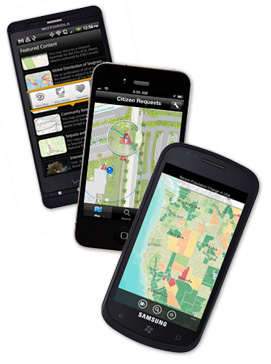
Mobile technologies keep growing in capabilities, diversity and availability by the week.  The decreasing prices of mobile devices and mobile services, better coverage and new software have made it one of the most dynamic services today - so no wonder that mobile GIS applications are getting more and more popular, both in the professional world and with the average outdoor enthusiast.

Being free from desktop hardware has many advantages. The user can easily use relatively cheap smartphones or tablets to access maps, collect and report data and even perform analysis. The software client interface is usually simpler, the costs of data collection can be greatly reduced and the data can be quickly synchronized with the client’s servers.


However, mobile technology has some drawbacks as well. The small screen size of smartphones, short battery life, limited keyboard functionality and limited processing power are some of the most common shortcomings of mobile GIS.

Nevertheless, most professional GIS software companies, such as ESRI and Google, are investing in this quickly developing market, constantly developing their mobile and online services. But there are also many start-ups and web communities that are developing their own mobile GIS solutions, that may be more easily adapted to personal users or small business needs. There are services that are available online and offline so not even a remote location is out of reach.


utorak, lipnja 10, 2014

ArcGIS Online, a map service for everyone

While working on the latest module of the UNIGIS master course, I am beginning to get acquainted with various online map services. One of the more interesting ones is the ArcGIS Explorer Online, available at http://www.arcgis.com/explorer.

The website offers many interesting user-made theme maps, such as World AIDS Day Map, Import and Export of Plastic Waste, Forest Areas in Europe, etc. These maps can serve as a good starting point or illustration for a student investigation or visual information for the interested public.

ArcGIS Explorer Online

But the real benefit of this map service is the ability to create (and publish) one’s own theme map. The ArcGIS Explorer offers base maps where a user can easily add information of interest, explore overlays and see associated data. You can look for information shared by other users based on keywords, import your own data or use your previously stored information. 


 Add Content in ArcGIS Explorer Online

In this way, the user can explore publicly available or personal data without the need for a professional and expensive software, and what is more, share this information with people he/she chooses or publish it for everyone to access.

For example, I investigated the occurrence of wildfires in the United States and produced a map that can be accessed here. It is fun and easy, really a tool for everyone.


An example of a completed map using public information of wildfire in the USA

And all you need is internet access and some imagination…

utorak, ožujka 04, 2014

More Deforestation Tools

Continuing on the last post, there is great news for those interested in deforestation. The World Resources Institute (WRI, USA) has launched a Global Forest Watch project (GFW) which claims to track forest loss "in near real time".

Making use of Landsat images, Google Earth Engine, Google Earth Maps and algorithms from the University of Maryland, the GFW will be a powerful tool for those needing up-to-date information. Organizations such as NGO's, local grassroot organizations but also politicians and  companies will be able to monitor the areas of particular interest for current information, monitoring the success of environmental policies or the far-trade status of their products.

An example of the areas of tree loss in Ecuador, from GFW project

"From now on, the bad guys cannot hide and the good guys will be recognized for their stewardship." said Dr Andrew Steer from WRI.
For more information, visit http://www.globalforestwatch.org/

Source: BBC News


srijeda, siječnja 01, 2014

Deforestation as seen by Google

Google Earth has been recently used to produce a detailed map of the world’s forest resources and how they have changed between 2000 and 2012. As reported by BBC, a research group at the University of Maryland used the free service to map the forest extent in 2000 and 2014 and then calculated deforestation and reforestation for the period. This interesting project shows how freely available data can be used for high-impact projects. 

Global Forest Change Project used  654,178 Landsat 7 images to document the loss of 2.3 million km2 and gain of 0.8 million km2 from 2000 to 2012. Brazil had marked a large success by reducing deforestation in this period, but this was offset by extreme deforestation in Indonesia, Malaysia, Paraguay and Angola. The largest forest loss was produced in the tropics (2101 km2/year), second by boreal forest loss. 


However, the positive news from Brazil may be too soon to start celebrating, reports the BBC. Brazilian minister Izabella Teixeira has recently commented that deforestation rate has increased by a staggering 28% between August 2012 and July 2013, despite the reduction in previous years.

Whatever the case may be, the Global Forest Change Project may prove to be a strong investigation tool, since it can be updated annually and at a fraction of a cost of commercial imaging services. This global imaging service may prove to be a strong information source to governments and activist groups in fighting illegal deforestation, control and planning, should they choose to use it.

For more information, visit the project map by the University of Maryland or read the original research article here.

subota, studenoga 30, 2013

So we begin... UNIGIS

Until now, this has been my personal travel blog. After I graduated, I went on a one-year trip across South and Central America and kept my family and friends updated through this medium, therefore the name Maja In The World. Most of the previous entries are in Croatian so not many of my GIS colleagues will be able to read it, so from this point on, I will write in English.

This blog will contain my experiences in the GIS world, my problems and successes and interesting GIS-related information that I find.


For the moment, I recommend this interesting website of the GIS Master program, UNIGIS, that I am taking and that I highly recommend.


So let the fun begin!
I may not have gone where I wanted to go, but I'm sure I ended up where I needed to be.